
The storm didn't just rain. It deposited an ocean.
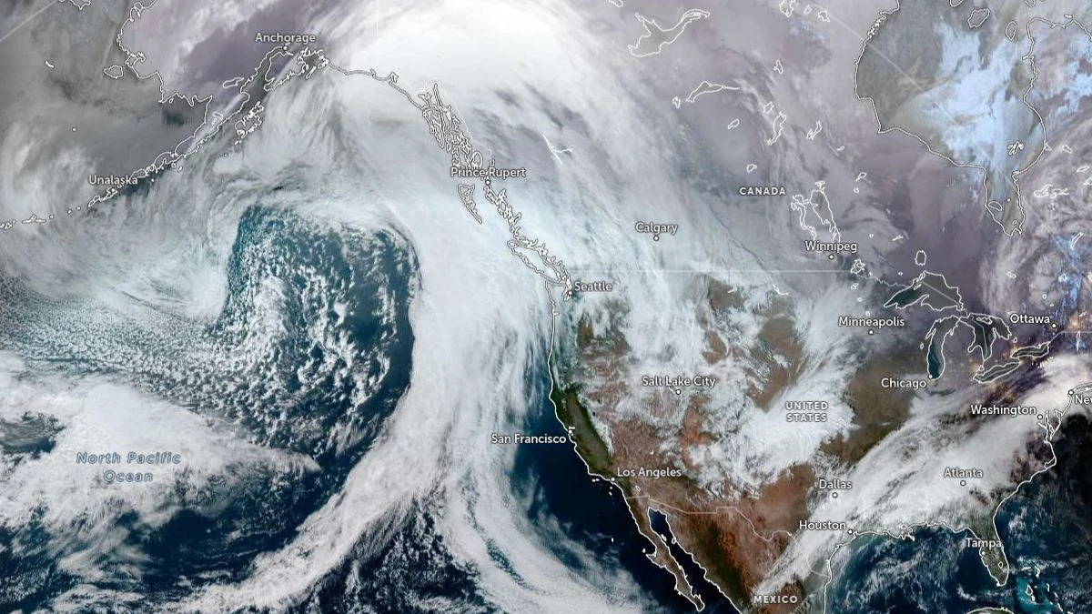
In January 2026, a single atmospheric river event dumped 28 inches of rainfall on coastal California in 72 hours — a volume that meteorologists privately described as "outside the historical envelope." Three hundred miles of highway washed out. Fourteen thousand homes flooded. The economic damage crossed $18 billion before insurance adjusters stopped counting. And here's the part that should terrify every urban planner on the planet: scientists say this was not the worst-case scenario. This was the new normal.
What Exactly Are 'Atmospheric Rivers 2.0'?
Atmospheric rivers — those narrow corridors of concentrated water vapor that can carry 15 times the water volume of the Mississippi River — have always existed. They're responsible for roughly 50% of all precipitation on the U.S. West Coast and drive significant rainfall events across Western Europe, South America, and southern Africa.
But "Atmospheric Rivers 2.0" is the term climate scientists at NOAA and the European Centre for Medium-Range Weather Forecasts (ECMWF) began deploying in late 2025 to describe a disturbing evolution: these systems are now running hotter, longer, wider, and more erratically than any climate model from the previous decade projected.
The mechanism is deceptively simple. A warmer atmosphere holds more moisture — approximately 7% more water vapor for every 1°C of warming, per the Clausius-Clapeyron equation. Earth's average surface temperature has now surpassed 1.5°C above pre-industrial baselines for the third consecutive year. The math writes itself.
"We're not just seeing stronger atmospheric rivers. We're seeing them behave in ways that break our categorization systems. They linger. They recharge. They stack." — Dr. Priya Nambiar, senior climate systems researcher, Scripps Institution of Oceanography
The Global Threat Map
This is no longer a California problem. The threat map has expanded dramatically, and the populations most at risk are precisely those with the least infrastructure to absorb catastrophic flooding.
Western Europe — The winter of 2025-26 saw back-to-back atmospheric river strikes across Portugal, Spain, and southern France. Lisbon recorded its highest three-day rainfall total in 400 years of recorded history. The Tagus River breached levees that were rebuilt after the 2024 floods, raising a grim question about whether permanent flood defenses are even economically viable when "100-year events" now arrive every 18 months.
East Africa and the Horn — Perhaps the most under-reported dimension of this crisis. Atmospheric rivers originating in the Indian Ocean have begun striking Somalia, Kenya, and Ethiopia with unprecedented intensity. In March 2026, an event described by Kenyan meteorologists as a "category 4 atmospheric river" triggered flash floods across six provinces, displacing over 400,000 people. Foreign aid pipelines, already strained by compounding crises, couldn't respond fast enough.
Chile and Argentina — The Andes amplify everything. Atmospheric rivers collide with mountain topography to produce orographic rainfall events of staggering intensity. Santiago's drainage systems, built to handle 50mm/day events, are regularly absorbing 200mm in under 24 hours. The city has flooded four times in the past 14 months.
Japan and South Korea — August 2025 brought a dual-event scenario: a typhoon feeding moisture into an atmospheric river over the Korean Peninsula. Seoul received a month's worth of rain in 11 hours. Infrastructure engineers call this a "compound hazard" — and models suggest compound events will double in frequency before 2030.
The Science Is Screaming. The Policy Is Whispering.
At the COP31 adaptation finance discussions in early 2026, atmospheric river risk barely cracked the top-10 agenda items. Flood defense budgets globally remain a fraction of what the projected damage curves demand.
The numbers are stark: